MapGO
MapGO is an online geospatial workspace for measuring distances, analyzing location data, and converting GIS files, with a generous free tier.
Overview
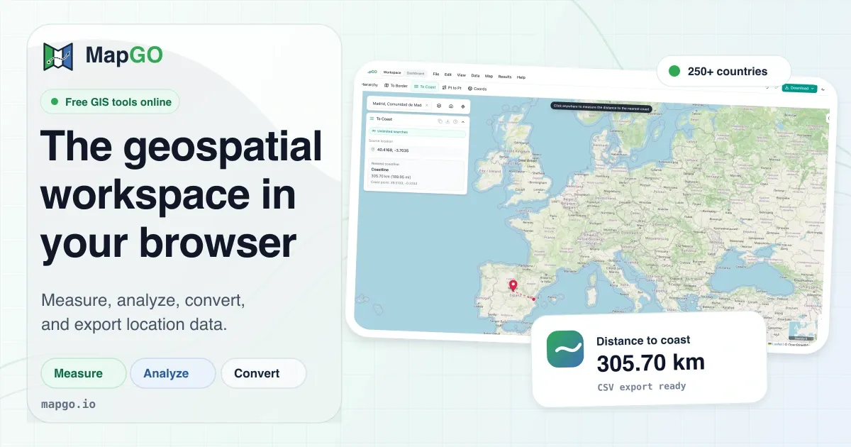
MapGO is a browser-based geospatial workspace that brings professional GIS capabilities to anyone with an internet connection. Rather than requiring desktop software installations or extensive GIS training, the platform offers an interactive map environment where users can measure distances, analyze administrative hierarchies, convert coordinate formats, and process bulk location data. The service positions itself as a modern alternative to traditional GIS tools, targeting developers, analysts, and businesses that need quick geospatial answers without the heavy lifting.
The market for geospatial software has historically been dominated by complex desktop applications like ArcGIS and QGIS, which come with steep learning curves and significant hardware demands. MapGO disrupts this model by running entirely in the browser, eliminating setup friction and enabling instant access from any device. The platform's own high-resolution coastline and boundary shapefile datasets power every measurement, covering more than 250 countries and territories with administrative subdivisions down to districts and sub-regions. This data foundation allows users to ask nuanced questions about location, such as "How far is this point from the nearest border?" or "What is the full administrative hierarchy for these coordinates?"
The product stands out for its dual approach: it offers both a visual workspace for interactive exploration and a REST API for programmatic access. This makes it useful for one-off spatial queries, as well as for integrating geospatial intelligence into external applications. The free tier, which provides up to ten lookups per day with an account, lowers the barrier for evaluation and small-scale projects. MapGO is a practical solution for anyone who has ever needed to calculate a distance, convert a coordinate, or understand the jurisdiction of a random point on the globe.
Key Features
Location Hierarchy Analysis
MapGO can take any coordinate and return the full administrative chain, from continent down to country, region, and district. The feature leverages the platform's detailed boundary datasets, which include regions and sub-regions for every country. For example, dropping a point in the middle of France would return the country, the administrative region such as Normandy, and the department or district. This is valuable for businesses that need to assign geographic context to user locations, understand market territories, or validate address data.
The hierarchy tool is designed for speed, delivering results in seconds even for points in remote or less-documented areas. It removes the need to maintain separate lookup tables or geographic databases, as MapGO handles the underlying data. The output is structured in a clear, readable format, making it easy to integrate into workflows or export for reporting purposes.
Distance to Border and Coastline
A standout feature is the ability to calculate the distance from any point to the nearest international border or coastline. Using the high-resolution shapefiles, MapGO computes these distances with a high degree of accuracy. The results are displayed in kilometers and can include the direction or bearing to the nearest boundary point. This is particularly useful for logistics companies planning routes that avoid borders, maritime industries assessing coastal proximity, or researchers studying geographic constraints.
The border distance calculation works at both country and regional levels, so users can measure distance to a province or state boundary, not just a national frontier. The coastline distance is based on a dedicated coastline dataset, providing reliable values for any landmass. For organizations that deal with territorial regulations, fisheries, or land use planning, these measurements become essential.
Point-to-Point Distance and Bearing
MapGO offers a straightforward tool for calculating the great-circle distance between two locations, along with the compass bearing and azimuth. Users can either click points on the map or input coordinates manually. The tool supports multiple coordinate formats, which is helpful when working with data from different sources. The bearing measurement is especially valuable for navigation, surveying, and any application that requires directional alignment between geographic points.
Beyond simple distance, the platform also measures areas by allowing users to draw polygons and read their size instantly. This is useful for property assessments, urban planning, or calculating coverage zones. The radius tool measures the distance from a center point to the edge of a circle, while the buffer tool creates a zone around a selected feature. These drawing and measurement capabilities make the workspace feel like a lightweight GIS application without the need to import shapefiles or manage layers.
GPS Coordinate Converter
Converting between coordinate formats is a routine but critical task for GIS professionals, surveyors, and hobbyists. MapGO's GPS converter handles three common formats: decimal degrees (DD), degrees/minutes/seconds (DMS), and degrees/minutes/minutes (DMM). Users can input coordinates in any of these notations and immediately see the equivalent values in the other formats. This eliminates the risk of miscommunication between teams that use different coordinate standards.
The converter is integrated into the larger workspace, so converted coordinates can be directly placed on the map for visual verification. This means a user can take a coordinate from an old DMS source, convert it to decimal degrees, and see exactly where it falls on the map, all in one session. The feature is simple but well executed, saving time and reducing errors associated with manual conversions.
File Conversion and Bulk CSV Processing
MapGO includes a dedicated file conversion tool that translates between common GIS formats: GeoJSON, KML, GPX, Shapefile, and CSV. Users can upload a file in one format and download the converted version without losing attributes or geometry. This is invaluable for importing data into different software ecosystems, whether moving from Google Earth's KML to a development-friendly GeoJSON or converting a surveyor's CSV into a shapefile for deeper analysis.
The bulk CSV processing feature is a differentiator. Users can upload a CSV file containing thousands of latitude/longitude rows, and MapGO will process them in a single job, enriching each row with administrative hierarchy, border distance, or other geospatial attributes. This turns a potentially tedious batch process into a one-click operation, making it easy to analyze large location datasets without writing custom code.
Developer API
MapGO exposes its core geospatial intelligence through a REST API available on RapidAPI. The API allows developers to integrate location hierarchy, border distance, coastline distance, and other features directly into their own applications. The endpoint returns structured JSON data, as demonstrated in the website's code snippet, showing the hierarchy, border distance, and coastline distance for a given coordinate pair. The API is designed for real-time use, with fast response times and a 99.9% uptime guarantee, making it suitable for production workloads.
The free tier of the API allows developers to experiment and build proofs of concept without upfront investment. This aligns with MapGO's overall freemium strategy, where the barrier to entry is low but paid plans scale with usage. For startups and enterprises that need location-aware functionality, the API provides a rapid path to implementation.
How It Works
The MapGO experience begins at the main website, where a user can either open the workspace directly or create a free account. The workspace is a full-screen interactive map with a side panel for tools and results. Upon first loading, the user sees a map interface similar to Google Maps, but with a suite of specialized tools accessible through buttons or menus.
To analyze a location, the user clicks on the map or enters coordinates. MapGO then displays the location hierarchy, distance to the nearest border, and distance to the nearest coastline in the results panel. This immediate feedback is the core value proposition, turning a vague geographic query into concrete answers in seconds. For example, clicking on central London would show the country as the United Kingdom, the region as England, the administrative district as the City of London, the distance to the nearest border (e.g., to Wales or Scotland), and the distance to the coast.
For measurement tasks, the user selects the desired tool, such as "Distance" or "Area," and then clicks on the map to define points or a polygon. The measurements update live as the user interacts, displaying the distance in kilometers or area in square kilometers. The drawing tools, including buffer and annotations, overlay the map and can be used to visually communicate zones or routes. All of this happens in the browser with no need to upload additional data unless the user chooses to bring in a file.
The file conversion workflow starts by navigating to the dedicated conversion page. The user uploads a file, selects the target format, and initiates the conversion. For CSV processing, the user uploads a file with lat/lng columns, specifies which columns contain the coordinates, and runs the bulk enrichment. The result is a downloadable file with the original data plus the newly appended geospatial attributes. Throughout the process, MapGO provides clear progress indicators and error messages when issues arise.
Registration is straightforward, requiring only an email address and password. The free account grants a daily quota of 10 lookups, while users who do not sign up are limited to 5 lookups per day. This freemium model encourages trial without forcing users to commit financially. The pricing page outlines paid tiers that increase the daily lookup limits and provide access to advanced features like higher API rate limits.
Use Cases
E-commerce Delivery Zone Planning
An online retailer with nationwide delivery needs to determine which product categories are eligible for same-day shipping based on warehouse proximity. Using MapGO's point-to-point distance and area tools, the logistics team can define delivery radii around each warehouse and visually assess coverage gaps. By loading a GeoJSON of its customer addresses, the team can also calculate the distance from each address to the nearest warehouse and adjust shipping fees accordingly. This reduces failed deliveries and improves customer satisfaction through accurate delivery estimates.
Environmental Research and Coastal Studies
A marine biology research group studies the impact of coastal pollution on shoreline habitats. They need to find the distance from sampling points to the nearest coastline and identify the administrative jurisdiction responsible for each location. MapGO's distance-to-coastline and location hierarchy features streamline this process. The researchers upload a CSV with hundreds of GPS coordinates from field samples, and MapGO enriches each point with its admin hierarchy and coastline distance. The output allows the team to filter samples by country or district and correlate pollution levels with distance to shore.
Real Estate and Property Analysis
Real estate analysts often need to answer questions like "Within which municipality does this parcel fall?" or "How close is this property to a national park?" With MapGO, an analyst can click on any point on the map and instantly see the administrative hierarchy, down to the district level. This is particularly useful when verifying property boundaries across multiple jurisdictions or when compiling reports for due diligence. The file conversion feature also lets analysts import a list of parcel coordinates from a CSV and export them as GeoJSON for use in mapping software, speeding up the data preparation workflow.
Field Service and Asset Management
Utility companies must maintain assets across vast geographic areas and often need to know which regulatory district or border proximity affects a particular site. Technicians can use MapGO to calculate the distance from an asset to the nearest international border, which is critical for cross-border operations or environmental compliance. The buffer tool allows managers to create exclusion zones around sensitive areas, such as pipelines or power lines, and visually inspect whether proposed assets fall within those zones. The browser-based nature of MapGO means technicians with a tablet can perform these checks in the field without specialized software.
Game Development and Virtual Geography
Game developers building location-based or open-world games often require realistic geographic reference points. Using MapGO's distance and bearing tools, developers can measure the distance between real-world locations to plan physical distances within their virtual game world. The coordinate converter helps translate real-world GPS data into game engine coordinate systems. Since MapGO runs in the browser, a developer can quickly verify a location without leaving their coding environment, making it a handy utility for indie studios.
Pricing & Value
MapGO adopts a freemium pricing model. According to the website, users can access up to 5 lookups per day without creating an account. Registering for a free account increases the daily limit to 10 lookups. No credit card is required to start using the service, which is an attractive entry point for individuals and small teams with basic needs.
The exact pricing for paid tiers is not detailed on the homepage, but the navigation includes a dedicated pricing page, which likely offers graduated plans with higher lookup quotas, API rate limits, and additional features such as priority support or bulk processing capabilities. The presence of a developer API on RapidAPI suggests that API usage may be metered separately, and users can purchase credits or subscriptions through that marketplace.
For a geospatial tool of this nature, the value proposition is strong. Traditional GIS platforms often charge several thousand dollars per year per license, while even lightweight spatial libraries require coding skill to use. MapGO offers a no-code visual interface for common calculations, making it accessible to non-developers. The ability to process bulk CSV files without writing scripts saves significant engineering time, and the API allows developers to automate geospatial queries at scale. The free tier is generous enough to support evaluation and low-volume personal use, while paid plans can scale to enterprise demands. Overall, MapGO presents a cost-efficient alternative for organizations that need occasional geospatial insights without investing in a full GIS stack.
Final Verdict
MapGO successfully positions itself as a friendly, browser-based entry point into the world of geospatial analysis. Its strengths lie in the breadth of built-in tools, the quality of the underlying geographical data, and the simplicity of the user interface. The ability to measure distances to borders and coastlines, understand administrative hierarchies, and convert files in several formats covers a wide range of practical needs. The inclusion of a developer API multiplies its utility, allowing businesses to embed these capabilities directly into their products.
There are a few areas where MapGO could improve. The lack of transparency about paid pricing on the homepage may cause hesitation for potential customers, and the lookup limits on the free tier could be restrictive for power users. Additionally, while the tools are well designed, they may not satisfy users who require advanced raster analysis, network routing, or 3D visualization, which are common in full-featured GIS platforms. However, for the majority of use cases involving point-based measurements and administrative lookups, MapGO delivers exceptional value.
This product is best suited for developers, logistics planners, analysts, and researchers who need fast, accurate geospatial answers without the overhead of desktop GIS. It also appeals to educators and hobbyists who want to explore geographic datasets interactively. With its generous free tier and straightforward pricing philosophy, MapGO is a practical choice for anyone looking to bring geospatial intelligence into their workflow.
Pros & Cons
The Good
- Provides instant distance-to-border and distance-to-coastline calculations using high-resolution boundary datasets covering 250+ countries.
- Offers a browser-based workspace that requires no installation or setup, making GIS tools accessible to non-experts.
- Includes a bulk CSV processing feature that enriches thousands of coordinates with administrative hierarchy and distances in one job.
- Supports conversion between several common GIS formats (GeoJSON, KML, GPX, Shapefile, CSV) in a single, easy-to-use interface.
- Provides a free tier with 10 lookups per day and no credit card requirement, generous for evaluation and small projects.
The Bad
- Pricing details for paid tiers are not prominently displayed on the home page, requiring a separate visit to the pricing page.
- The free tier's daily lookup limit (10 per day) may be too restrictive for active users or larger data processing needs.
- Advanced GIS functions such as raster analysis, network routing, or 3D visualization are not available, limiting use for complex spatial projects.